
The TOTEM (Tagging of Oceanic Teleost and Elasmobranch ![]() Megafauna) Project is a collaborative effort that includes researchers in the the Fish Ecology Lab at the Woods Hole Oceanographic Institution, the Massachusetts Department of Fisheries (Dr. Greg Skomal), the University of the Azores (Dr. Pedfro Afonso and Dr. Jorges Fontes) and local ocean conservation advocates (Tom Burns, DVM and Eric Savetsky), fishermen (Captain Willy Hatch) and pilots (Wayne Davis). The project was launched in the summer of 2012 and has included tagging expeditions to the western North Atlantic, the Azores, the Red Sea and the central tropical Pacific. On these expeditions we have tagged basking sharks, blue sharks, makos, swordfish and mobulid rays using a combination of Smart POsition and Temperature (SPOT) and Pop-up Satellite Archival Transmitting (PSAT) tags. The TOTEM project is leveraging private philanthropic and government funds to provide a unique view of the lives of the largest fishes in the oceans. These data are in turn be shared with appropriate governmental, inter-governmental and non-governmental organizations tasked with the conservation and sustainable management of these populations in the Atlantic.
Megafauna) Project is a collaborative effort that includes researchers in the the Fish Ecology Lab at the Woods Hole Oceanographic Institution, the Massachusetts Department of Fisheries (Dr. Greg Skomal), the University of the Azores (Dr. Pedfro Afonso and Dr. Jorges Fontes) and local ocean conservation advocates (Tom Burns, DVM and Eric Savetsky), fishermen (Captain Willy Hatch) and pilots (Wayne Davis). The project was launched in the summer of 2012 and has included tagging expeditions to the western North Atlantic, the Azores, the Red Sea and the central tropical Pacific. On these expeditions we have tagged basking sharks, blue sharks, makos, swordfish and mobulid rays using a combination of Smart POsition and Temperature (SPOT) and Pop-up Satellite Archival Transmitting (PSAT) tags. The TOTEM project is leveraging private philanthropic and government funds to provide a unique view of the lives of the largest fishes in the oceans. These data are in turn be shared with appropriate governmental, inter-governmental and non-governmental organizations tasked with the conservation and sustainable management of these populations in the Atlantic.
Whale sharks are seasonal visitors to the Northeast Canyons and Seamounts Marine National Monument but their movements during the rest of the year remain unknown.
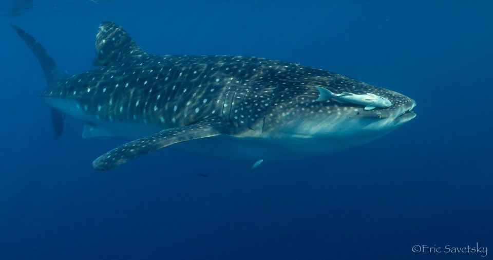
We are launching a major new effort in the spring of 2017 to tag whale sharks (Rhincodon typus) and devil rays (Mobula tarapacana) at the canyons off southern New England in the vicinity of new Northeast Canyons and Seamounts Marine National Monument. Whale sharks and devil rays are seasonal visitors to the canyons on the outer edge of the continental shelf where they are occasionally encountered by fishermen. We know nothing about the movements of these elasmobranchs in the northwest Atlantic, and where they go after leaving the canyons remains a mystery. However, Tom Burns and Eric Savetsky were able to deploy a SPOT6 towed tag on a 5m whale shark in the summer of 2016 in Oceanographer’s Canyon, off the south coast of Nantucket. The resulting track (below) shows the shark initially moving north and then south along the edge of the continental shelf before heading offshore adjacent to Cape Hatteras. The shark then moved northeast with the Gulf Stream in a highly energetic area of the ocean characterized by Gulf Stream meanders and eddies off southern New England. Click here to check out the shark’s latest movements hosted on the OCEARCH Shark tracker website. We will resume tagging efforts in the early summer of 2017 and are planning to tag as many whale sharks and Mobula tarapacana as possible through October. Ultimately we hope to be able to identify the oceanographic features underpinning the movements of these animals. This knowledge will, in turn, allow us to develop habitat utilization models that can be used to predict potential threats from interactions with fishing gear and the likely impacts of climate change on migration pathways.
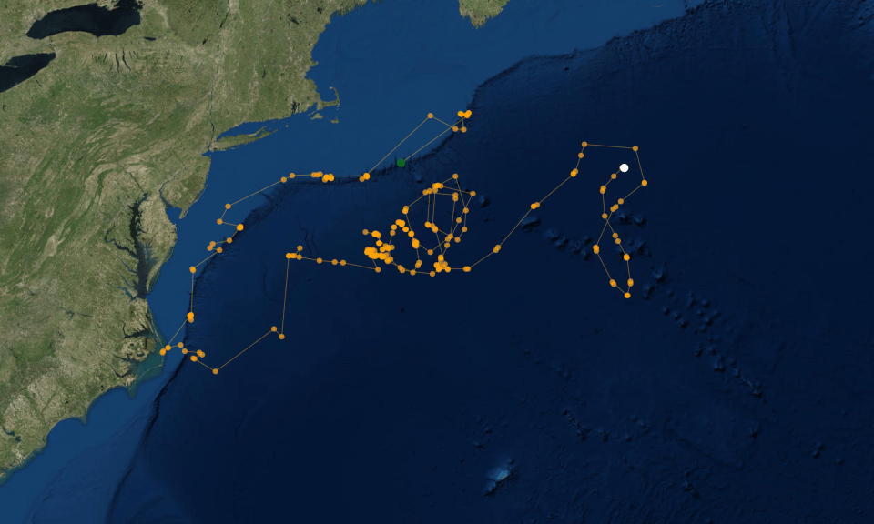
Track of whale shark tagged at Oceanographer Canyon (green dot) in the summer of 2016. Latest position (white dot) as of mid December, 2016.
